Oroville Dam 2 - SMT M 🦊
- 14 görüntülenme
Bu model Creality Cloud üzerinde barındırılıyor. Dosyalar, görseller ve lisans bilgileri tasarımcısına aittir.
Creality Cloud üzerinde görüntüle ↗Açıklama
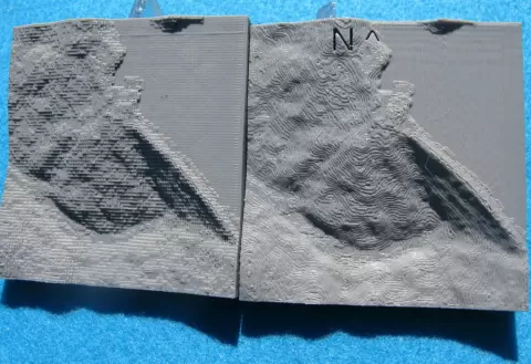
A second look at the Oroville dam using ASTER data ("ASTER GEDEM is a product of METI and NASA"). Two relief maps have been calculated using 10,000 data points centered near the dam. The vertical scale has been exaggerated to more clearly show detail. As before a map, ver_1, has been calculated using an openSCAD surface file. A second map, ver_2, was formed by stacking 10,000 rectangular bricks with heights proportional to the data points. Flat surfaces representing the height of each pixel can be seen in the stl file. It has visual appeal and is a reminder of the limitations of the data. Fortran and openSCAD code are included. A new view of the dam was added on March 3, 2017
Bu model hakkında
Oroville Dam 2 - SMT M 🦊, Creality Cloud topluluğunda paylaşılan ücretsiz bir Diğer 3D modelidir. 3D baskı için indirebilir ve orijinal lisans koşulları çerçevesinde kendi projelerinde kullanabilirsin.
Dosya formatları
- STL — 3D baskı için en yaygın mesh formatı — neredeyse her yazıcıda dilimlenip basılmaya hazır.
Bu modelin dosyaları Creality Cloud üzerinde barındırılır. Orijinal sayfayı açıp indirmek için yukarıdaki düğmeyi kullan.